A multidisciplinary approach using the integrated field of geosciences (e.g., geomorphology, geotectonics, geophysics, and hydrology) is established to conduct groundwater recharge potential mapping of the Kunur River Basin, India. The relative mean error (RME) calculation of the results of three applied techniques and water table data from twenty-four observation wells in the basin over the 2000-2010 period are presented. Nine sub-basins were identified and ranked for the RME calculation, where the observation wells-based ranking was taken as standard order for comparison. A linear model has been developed using six factors (drainage density, surface slope, ruggedness index, lineament density, Bouguer gravity anomaly, and potential maximum water retention capacity) and a grid-wise weighted index. In a separate comparative approach, the sub-basin and grid-wise analyses have been conducted to identify the suitable spatial unit for watershed level hydrological modeling.
Diagenesis exerts an important control on porosity evolution, and research of diagenesis and diagenetic minerals provides insights into reservoir quality evaluation and CO2 storage. Thin section, XRD (X-ray diffraction), CT (Computed Tomography), scanning electron microscopy (SEM), and NMR (Nuclear Magnetic Resonance) tests were used to investigate composition, texture, pore spaces, and diagenesis of sandstones in Paleogene Dongying Formation in Bohai Bay Basin, China, with special aims to unravel diagentic dissolution along bedding planes. The oversized pores, remnants in feldspar-hosted pores, and kaolinite within feldspar grains indicate a high degree of dissolution the framework grains experienced during burial. The CO2-rich or organic acids are responsible for the feldspar dissolution. Grain size plays the primary role in enhancing bedding dissolution process, and bedding planes in fine-medium grained sandstones with high content of feldspars are frequently enlarged by dissolution. The CT scanning image confirms dissolution pores are distributed discontinuously along the bedding planes. The dissolution pores along bedding planes have large pore size, and correspond to the right peak of the bi-modal T2 (transverse relaxation time) spectrum. The laminated sandstones and siltstones, or sandstones with cross beddings help improve framework grain dissolution. These new findings help improve the understanding of diagenetic models, and have implications in reservoir quality prediction and resource assessments in sandstones.

Shale gas is a relatively clean-burning fossil fuel, produced by hydraulic fracturing. This technology may be harmful to the environment; therefore, environmentally friendly methods to extract shale gas have attracted considerable attention from researchers. Unlike previous studies, this study is a comprehensive investigation that uses systematic analyses and detailed field data. The environmental challenges associated with shale gas extraction, as well as measures to mitigate environmental impacts from the source to end point are detailed, using data and experience from China’s shale gas production sites. Environmental concerns are among the biggest challenges in practice, mainly including seasonal water shortages, requisition of primary farmland, leakage of drilling fluid and infiltration of flowback fluid, oil-based drill cuttings getting buried underground, and induced seismicity. China’s shale gas companies have attempted to improve methods, as well as invent new materials and devices to implement cleaner processes for the sake of protecting the environment. Through more than 10-year summary, China’s clean production model for shale gas focuses on source pollution prevention, process control, and end treatment, which yield significant results in terms of resource as well as environmental protection, and can have practical implications for shale gas production in other countries, that can be duplicated elsewhere.

China’s rapid economic development has initiated the deterioration of its ecological environment, posing a threat to the sustainable development of human society. As a result, an assessment of regional sustainability is critical. This paper researches China’s most forested province, Fujian Province, as the study area. We proposed a grid-based approach to assess the regional carbon footprint in accordance with the Intergovernmental Panel on Climate Change’s (IPCC) carbon emission guidelines. Our method of assessment also introduced carbon emission indicators with our improved and published Net Primary Production (NPP) based on process simulation. The carbon footprint in Fujian Province from 2005–2017 was calculated and examined from a spatiotemporal perspective. Ecological indicators were used in the sustainability assessment. The research draws the following conclusions: 1) the carbon footprint in the eastern regions of Fujian Province was higher due to rapid economic development; 2) that of the western regions was lower; 3) an uptrend in the carbon footprint of Fujian Province was observed. All five ecological indicators based on carbon emissions and economic and social data showed an ecologically unsustainable trend over 13 years in the research area due to unsustainable economic development. Therefore, it is urgent to balance the relationship between economic development and environmental protection. Our research provides scientific references for achieving ecological civilization and sustainability in a similar region.
High- and low-rank coalbed methane (CBM) are both important fields of CBM development in China, but their formation and production mechanisms differ considerably. The adsorption/desorption behavior of high- and low-rank coals under the coupling of coal–water–gas was investigated using two series of samples. Coal samples from Zhangjiamao (ZJM) coal mine, Ordos basin, and Sihe (SH) coal mine, Qinshui basin, were tested by isothermal adsorption–desorption experiment, natural imbibition experiment, nuclear magnetic resonance, mercury injection porosimetry, contact angle test, and permeability test. Isothermal adsorption and desorption experiments under dry, equilibrium water, and saturated water, were performed to explore the differences between the adsorption and desorption characteristics. The results show that the wettability and permeability of the ZJM low-rank coal sample was considerably higher than that of the SH high-rank coal sample. The imbibition process of the ZJM sample exhibited a high imbibition rate and high total-imbibition volume, whereas the SH sample exhibited a slow imbibition rate and low total-imbibition volume. The ZJM sample had a complex pore structure and diverse pore-size distribution with a lower mercury withdrawal efficiency at 59.60%, whereas the SH sample had a relatively uniform pore-size distribution with a higher mercury withdrawal efficiency at 97.62%. The response of adsorption and desorption of the ZJM sample to water was more significant than that of the SH sample. The desorption hysteresis of the ZJM sample was stronger than that of the SH sample and was more prominently affected by water, which was consistent with its strong wettability and complex pore-throat configuration. A comprehensive adsorption and desorption mode was constructed for high- and low-rank coal samples under coal–water–gas coupling condition. The research results are important to enrich the geological theory of high- and low-rank CBM and to guide efficient CBM recovery.

Petrophysics of coals directly affects the development of coalbed methane (CBM). Based on the analysis of the representative academic works at home and abroad, the recent progress on petrophysics characteristics was reviewed from the aspects of the scale-span pore-fracture structure, permeability, reservoir heterogeneity, and its controlling factors. The results showed that the characterization of pore-fracture has gone through three stages: qualitative and semiquantitative evaluation of pore-fracture by various techniques, quantitatively refined characterization of pore-fracture by integrating multiple methods including nuclear magnetic resonance analysis, liquid nitrogen, and mercury intrusion, and advanced quantitative characterization methods of pore-fracture by high-precision experimental instruments (focused-ion beam-scanning electron microscopy, small-angle neutron scattering and computed tomography scanner) and testing methods (m-CT scanning and X-ray diffraction). The effects of acoustic field can promote the diffusion of CBM and generally increase the permeability of coal reservoirs by more than 10%. For the controlling factors of reservoir petrophysics, tectonic stress is the most crucial factor in determining permeability, while the heterogeneity of CBM reservoirs increases with the enhancement of the tectonic deformation and stress field. The study on lithology heterogeneity of deep and high-dip coal measures, the spatial storage-seepage characteristics with deep CBM reservoirs, and the optimizing production between coal measures should be the leading research directions.

Tight sandstone reservoirs are generally characterized by complex reservoir quality, non-Darcy flow, and strong heterogeneity. Approaches utilized for evaluating physical property cutoffs of conventional reservoirs maybe inapplicable. Thus, a comprehensive investigation on physical property cutoffs of tight sandstone reservoirs is crucial for the reserve evaluation and successful exploration. In this study, a set of evaluation approaches take advantage of field operations (i.e., core drilling, oil testing, and wireline well logging data), and simulation experiments (i.e., high-pressure mercury injection-capillary pressure (MICP) experiment, oil-water relative permeability experiment, nuclear magnetic resonance (NMR) experiment, and biaxial pressure simulation experiment) were comparatively optimized to determine the physical property cutoffs of effective reservoirs in the Upper Triassic Chang 6, Chang 8 and Chang 9 oil layers of the Zhenjing Block. The results show that the porosity cutoffs of the Chang 6, Chang 8, and Chang 9 oil layers are 7.9%, 6.4%, and 8.6%, and the corresponding permeability are 0.08 mD, 0.05 mD, and 0.09 mD, respectively. Coupled with wireline well logging, mud logging, and oil testing, the cut-off of the thickness of single-layer effective reservoirs are approximately 3.0 m, 3.0 m, and 2.0 m, respectively. Depending on the cutoffs of critical properties, a superimposed map showing the planar distribution of the prospective targets can be mapped, which may delineate the effective boundary of prospective targets for petroleum exploration of tight sandstone reservoirs.

Water is the essential resource of the 21st century where innovative water management strategies are needed to improve water security. This paper examines three case studies that exemplify the global water crisis, situated in rapidly urbanizing watersheds: Nairobi River Basin, Kenya; Citarum River Basin, Indonesia; and Addis Ababa River Basin, Ethiopia. Each of these watersheds are implementing large-scale water management strategies inclusive of local communities and regional governments to address water quality and waste management issues. The hydrosocial cycle (Linton, 2010) provides a framework to investigate the social, technical and physical aspects of water flows. Using the hydrosocial cycle as an organizing framework, these watersheds are examined to highlight how water security underpins water justice. The issues of gender and inequity are often overlooked in larger policy, development, and infrastructure discussions where technical requirements, restoration management, and engineering solutions obscure power inequities. Projects are compared to assess the implementation of the hydrosocial cycle through a discussion of social power and structure, technology and infrastructure, and the materiality of water in each location. This comparison reveals a dependence on large-scale technical projects with limited community engagement, and a need for science-based river restoration management. Recommendations are provided to improve and address holistic water management.
Natural fractures are of crucial importance for oil and gas reservoirs, especially for those with ultralow permeability and porosity. The deep-marine shale gas reservoirs of the Wufeng and Longmaxi Formations are typical targets for the study of natural fracture characteristics. Detailed descriptions of full-diameter shale drill core, together with 3D Computed Tomography scans and Formation MicroScanner Image data acquisition, were carried out to characterize microfracture morphology in order to obtain the key parameters of natural fractures in such system. The fracture type, orientation, and their macroscopic and microscopic distribution features are evaluated. The results show that the natural fracture density appears to remarkably decrease in the Wufeng and Longmaxi Formations with increasing the burial depth. Similar trends have been observed for fracture length and aperture. Moreover, the natural fracture density diminishes as the formation thickness increases. There are three main types of natural fractures, which we interpret as (I) mineral-filled fractures (by pyrite and calcite), i.e., veins, (II) those induced by tectonic stress, and (III) those formed by other processes (including diagenetic shrinkage and fluid overpressure). Natural fracture orientations estimated from the studied natural fractures in the Luzhou block are not consistent with the present-day stress field. The difference in tortuosity between horizontally and vertically oriented fractures reveals their morphological complexity. In addition, natural fracture density, host rock formation thickness, average total organic carbon and effective porosity are found to be important factors for evaluating shale gas reservoirs. The study also reveals that the high density of natural fractures is decisive to evaluate the shale gas potential. The results may have significant implications for evaluating favorable exploration areas of shale gas reservoirs and can be applied to optimize hydraulic fracturing for permeability enhancement.

A varied class method is applied to calculate the effective discharges and their variations after the Three Gorges Dam (TGD) construction based on the mean daily flow discharge and suspended sediment concentration field data from 1981 to 2016. For comparison, the bankfull discharges are also determined according to the cross-section profiles and flow discharge-stage relations. Our results show that a bimodal effective discharge curve usually exists at the fixed sites, which generates two effective discharges (Qe1 and Qe2) within the moderate flow range. Under the quasi-equilibrium circumstances of the pre-dam period, effective discharges are closely related to the mean annual runoff, with a narrow range of regional variations in occurrence frequency. Our analyses draw the conclusion that the relatively higher unsaturation degrees of the pre-dam effective discharges caused by dam interception and riverbed coarsening are the primary cause of the increase in effective discharges from Yichang to Shashi, while the more frequent low and medium discharges due to flow regulation drive the decrease in effective discharges from Jianli to Datong. The slightly elevated flood levels and descending bankfull levels collaboratively result in the decrease of bankfull discharges from Yichang to Shashi, while the lowered bed elevation causes the increase in bankfull discharges from Luoshan to Datong. Overall, the bankfull discharge in the Middle and Lower Yangtze River is larger than effective discharge and approaches the 1.5- year recurrence interval discharge.
Considering snowmelt in mountainous areas as the important source of streamflow, the snow accumulation/melting processes are vital for accurate simulation of the hydrological regimes. The lack of snow-related data and its uncertainties/conceptual ambiguity in snowpack modeling are the different challenges of developing hydro-climatological models. To tackle these challenges, Global Gridded Snow Products (GGSPs) are introduced, which effectively simplify the identification of the spatial characteristics of snow hydrological variables. This research aims to investigate the performance of multi-source GGSPs using multi-stage calibration strategies in hydrological modeling. The used GGSPs were Snow-Covered Area (SCA) and Snow Water Equivalent (SWE), implemented individually or jointly to calibrate an appropriate water balance model. The study area was a mountainous watershed located in Western Iran with a considerable contribution of snowmelt to the generated streamflow. The results showed that using GGSPs as complementary information in the calibration process, besides streamflow time series, could improve the modeling accuracy compared to the conventional calibration, which is only based on streamflow data. The SCA with NSE, KGE, and RMSE values varying within the ranges of 0.47–0.57, 0.54–0.65, and 4–6.88, respectively, outperformed the SWE with the corresponding metrics of 0.36–0.59, 0.47–0.60, and 5.22–7.46, respectively, in simulating the total streamflow of the watershed. In addition to the superiority of the SCA over SWE, the two-stage calibration strategy reduced the number of optimized parameters in each stage and the dependency of internal processes on the streamflow and improved the accuracy of the results compared with the conventional calibration strategy. On the other hand, the consistent contribution of snowmelt to the total generated streamflow (ranging from 0.9 to 1.47) and the ratio of snow melting to snowfall (ranging from 0.925 to 1.041) in different calibration strategies and models resulted in a reliable simulation of the model.

The annual peak growth and trend shift of vegetation are critical in characterizing the carbon sequestration capacity of ecosystems. As the well-known area with the fastest vegetation growth in the world, the Loess Plateau (LP) lands find an enhanced greening trend in the annual and growing-season. However, the spatiotemporal dynamics of vegetation peak growth and breakpoints characteristics on time series still needs to be explored. Here, we performed tendency analysis to characterize recent variations in annual peak vegetation growth through a satellite-derived vegetation index (NDVImax, Maximum Normalized Difference Vegetation Index) and then applied breakpoint analysis to capture abrupt points on the time series. The results demonstrated that the vegetation peak trend had been significantly increasing, with a growth rate at 0.68×10⁻²·a–1 during 2001–2018, and most pixels (70.81%) have a positive linear greening trend over the entire LP. In addition, about 83% of the breakpoint type on the monthly NDVI time series is a monotonic increase at the pixel level, and most pixels (57%) have detected breakpoints after 2010. Our results also showed that the growth rate accelerates in the northwest and decelerates in the southeast after the breakpoint. This study indicates that combining abrupt analysis with gradual analysis can describe vegetation dynamics more effectively and comprehensively. The findings highlighted the importance of breakpoint analysis for monitor timing and shift using time series satellite data at a regional scale, which may help stakeholders to make reasonable and effective ecosystem management policies.
The stability of dawsonite is an important factor affecting the feasibility evaluation of CO2 geological storage. In this paper, a series of experiments on the interaction of CO2-water-dawsonite-bearing sandstone were carried out under different CO2 pressures. Considering the dissolution morphology and element composition of dawsonite after the experiment and the fluid evolution in equilibrium with dawsonite, the corrosion mechanism of dawsonite led by CO2 partial pressure was discussed. The CO2 fugacity of the vapor phase in the system was calculated using the Peng–Robinson equation of state combined with the van der Waals 1-fluid mixing rule. The experimental results indicated that the thermodynamic stability of dawsonite increased with the increase of CO2 partial pressure and decreased with the increase of temperature. The temperature at which dawsonite dissolution occurred was higher at higher
Considering the complementarity of synchrotron radiation SAXS and nano-CT in the pore structure detection range, synchrotron radiation SAXS and nano-CT methods were combined to characterize the nano- to micro-pore structure of two bituminous coal samples. In mesopores, the pore size distribution curves exhibit unimodal distribution and the average pore diameters are similar due to the affinity of metamorphic grades of the two samples. In macropores, the sample with higher mineral matter content, especially clay mineral content, has a much higher number of pores. The fractal dimensions representing the pore surface irregularity and the pore structure heterogeneity were also characterized by synchrotron radiation SAXS and nano-CT. The fractal dimensions estimated by both methods for different pore sizes show consistency and the sample with smaller average pore diameters has a more complex pore structure within the full tested range.

As one of the most devastating tropical cyclones over the western North Pacific Ocean, Super Typhoon Lekima (2019) has caused a wide range of heavy rainfall in China. Based on the CMA Multi-source merged Precipitation Analysis System (CMPAS)-hourly data set, both the temporal and spatial distribution of extreme rainfall is analyzed. It is found that the heavy rainfall associated with Lekima includes three main episodes with peaks at 3, 14 and 24 h after landfall, respectively. The first two rainfall episodes are related to the symmetric outburst of the inner rainband and the persistence of outer rainband. The third rainfall episode is caused by the influence of cold, dry air from higher latitudes and the peripheral circulation of the warm moist tropical storm. The averaged rainrate of inner rainbands underwent an obvious outburst within 6 h after landfall. The asymmetric component of the inner rainbands experienced a transport from North (West) quadrant to East (South) quadrant after landfall which was related to the storm motion other than the Vertical Wind Shear (VWS). Meanwhile the outer rainband in the vicinity of three times of the Radius of Maximum Wind (RMW) was active over a 12-h period since the decay of the inner rainband. The asymmetric component of the outer rainband experienced two significant cyclonical migrations in the northern semicircle.

Nowadays, autonomous driving has been attracted widespread attention from academia and industry. As we all know, deep learning is effective and essential for the development of AI components of Autonomous Vehicles (AVs). However, it is challenging to adopt multi-source heterogenous data in deep learning. Therefore, we propose a novel data-driven approach for the delivery of high-quality Spatio-Temporal Trajectory Data (STTD) to AVs, which can be deployed to assist the development of AI components with deep learning. The novelty of our work is that the meta-model of STTD is constructed based on the domain knowledge of autonomous driving. Our approach, including collection, preprocessing, storage and modeling of STTD as well as the training of AI components, helps to process and utilize huge amount of STTD efficiently. To further demonstrate the usability of our approach, a case study of vehicle behavior prediction using Long Short-Term Memory (LSTM) networks is discussed. Experimental results show that our approach facilitates the training process of AI components with the STTD.

Crystallinity, polytype, and morphology of clay minerals in the Luochuan loess-palaeosols in Shaanxi Province, northwest China were studied in order to have an insight into their origin using X-ray diffraction (XRD) analysis and scanning electron microscopy (SEM) methods. The SEM observations showed that the morphology of some illites seems to be lath-shaped crystals. An analysis of illite crystallinity (IC) on the Luochuan section indicated that the origin of illite was related to the rocks of an anchizone. Most illite in the Luochuan loess-palaeosol section were of 2M1 polytype, but some were of 1M polytype formed by weathering of feldspar in the process of pedogenesis. Illite in the Luochuan section has undergone both physical and chemical weathering. These results revealed that most illite were of detrital origin related to the source area of an anchizone, but parts of the illite were of an authigenic origin formed during pedogenesis after sedimentation. Chlorites in the samples of the Luochuan section were mainly composed of irregular flaky grains and their crystallinity was good. These showed that chlorite had the detrital origin formed by physical weathering. Kaolinite crystallinity was relatively good. The value of CIA on the Luochuan section ranges from 61.9 to 69, and therefore kaolinite could not be formed during weathering and pedogenesis. These results indicated that the kaolinite had a detrital origin. Morphology of smectite seems to be capillaceous. The XRD patterns of all samples contained diffraction peaks at 1.5218 Å (nontronite) and 1.5052 Å (montmorillonite), thus indicating an intermediate composition between trioctahedral and dioctahedral smectite. The smectite crystallinity was very poor. These results revealed that smectite in the study area was authigenic rather than detrital origin.
The sandstone of the third member of the Funing Formation (E1f3) in the northern slope zone of the Gaoyou Sag has the typical characteristics of high porosity and ultralow permeability, which makes it difficult for oil to flow. In this study, the lithological characteristics, sedimentary facies, diagenetic characteristics, pore structure, and seepage ability of this sandstone are characterized in detail. Correlation analysis is used to reveal the reason for the sandstone high porosity-low permeability phenomenon in the study area. The results indicate that this phenomenon is controlled mainly by the following three factors: 1) the sedimentary environment is the initial affecting factor, whereby the deposition of a large number of fine-grained materials reduces the primary pores of sandstone. 2) The Funing Formation has undergone strong compaction and cementation, which have led to the removal of most of the primary pores and a reduction in size of the throat channels. 3) Owing to fluid activity during the later stage of diagenesis, sandstone underwent intense dissolution and a large number of particles (feldspar and lithic debris) formed many dissolution pores (accounting for nearly 60% of the total pore space). Among these factors, dissolution has contributed the most to the development of high porosity-low permeability phenomenon. This is mainly attributed to the inhomogeneous dissolution process, whereby the degree of particle dissolution (e.g. feldspar) exceeds that of cementing minerals (clay and carbonate minerals). The secondary dissolution pores have increased the porosity of sandstone in the study area; however, the pore connectivity (permeability) has not been significantly improved, thus resulting in the special high porosity-low permeability characteristics of this sandstone.

Long-chain n-alkanes are one of the most common organic compounds in terrestrial plants and they are well-preserved in various geological archives. n-alkanes are relatively resistant to degradation and thus they can provide high-fidelity records of past vegetation and climate changes. Nevertheless, previous studies have shown that the interpretation of n-alkane proxies, such as the average chain length (ACL), is often ambiguous since this proxy depends on more than one variable. Both vegetation and climate could exert controls on the n-alkane ACL, and hence its interpretation requires careful consideration, especially in regions like the Qinghai-Tibet Plateau (QTP) where topography, biome type and moisture source are highly variable. To further evaluate the influences of vegetation and climate on the ACL in high-elevation lakes, we examined the n-alkane distributions of the surface sediments of 55 lakes across the QTP. Our results show that the ACL across a climatic gradient is significantly affected by precipitation, rather than by temperature. The positive correlation between ACL and precipitation may be because of the effect of microbial degradation during deposition. Finally, we suggest that more caution is needed in the interpretation of ACL data in different regions.

Lacustrine shale oil resources in China are abundant, with remarkable exploration breakthroughs being achieved. Compared to marine shale oil in North America, efficient exploration of lacustrine shale oil is more difficult; thus, selecting favorable layer and optimization zone for horizontal wells is more important. In this study, based on systematic coring of approximately 500 m fine-grained deposits of the Kong 2 Member, combining laboratory tests and log data, source rock geochemistry and reservoir physical properties, the favorable rock fabric facies for oil accumulation was analyzed and classified. First, the dominant lithologic facies, organic facies, and bed combination facies were determined based on mineral composition from logging, total organic content (TOC), and sedimentary structure. Secondly, 10 fabric facies were classified by combining these three facies, with 4 fabric facies were found to have high TOC content, high total hydrocarbon, and strong fluorescence features, indicating good shale oil enrichment. Thirdly, the distribution of the upon good fabric facies was identified to be located at the top of the Kong 2 Member, with evidences of seismic resistivity inversion, thermal maturity, structure depth, and strata thickness. And the favorable facies were found to be stably distributed lateral at the area of about 100 km2. High oil flow has been detected at this layer within this area by several wells, including horizontal wells. The exploratory study of fabric facies classification and evaluation provides a new research idea for lacustrine shale oil exploration and effectively promotes breakthroughs in lacustrine shale oil exploration in Bohai Bay Basin.
Long-term rainfall data are crucial for flood simulations and forecasting in karst regions. However, in karst areas, there is often a lack of suitable precipitation data available to build distributed hydrological models to forecast karst floods. Quantitative precipitation forecasts (QPFs) and estimates (QPEs) could provide rational methods to acquire the available precipitation data for karst areas. Furthermore, coupling a physically based hydrological model with QPFs and QPEs could greatly enhance the performance and extend the lead time of flood forecasting in karst areas. This study served two main purposes. One purpose was to compare the performance of the Weather Research and Forecasting (WRF) QPFs with that of the Precipitation Estimations through Remotely Sensed Information based on the Artificial Neural Network-Cloud Classification System (PERSIANN-CCS) QPEs in rainfall forecasting in karst river basins. The other purpose was to test the feasibility and effective application of karst flood simulation and forecasting by coupling the WRF and PERSIANN models with the Karst-Liuxihe model. The rainfall forecasting results showed that the precipitation distributions of the 2 weather models were very similar to the observed rainfall results. However, the precipitation amounts forecasted by WRF QPF were larger than those measured by the rain gauges, while the quantities forecasted by the PERSIANN-CCS QPEs were smaller. A postprocessing algorithm was proposed in this paper to correct the rainfall estimates produced by the two weather models. The flood simulations achieved based on the postprocessed WRF QPF and PERSIANN-CCS QPEs coupled with the Karst-Liuxihe model were much improved over previous results. In particular, coupling the postprocessed WRF QPF with the Karst-Liuxihe model could greatly extend the lead time of flood forecasting, and a maximum lead time of 96 h is adequate for flood warnings and emergency responses, which is extremely important in flood simulations and forecasting.
Global maps of bioclimatic variables currently exist only at very coarse spatial resolution (e.g. WorldClim). For ecological studies requiring higher resolved information, this spatial resolution is often insufficient. The aim of this study is to estimate important bioclimatic variables of Mongolia from Earth Observation (EO) data at a higher spatial resolution of 1 km. The analysis used two different satellite time series data sets: land surface temperature (LST) from Moderate Resolution Imaging Spectroradiometer (MODIS), and precipitation (P) from Climate Hazards Group Infrared Precipitation with Stations (CHIRPS). Monthly maximum, mean, and minimum air temperature were estimated from Terra MODIS satellite (collection 6) LST time series product using the random forest (RF) regression model. Monthly total precipitation data were obtained from CHIRPS version 2.0. Based on this primary data, spatial maps of 19 bioclimatic variables at a spatial resolution of 1 km were generated, representing the period 2002–2017. We tested the relationship between estimated bioclimatic variables (SatClim) and WorldClim bioclimatic variables version 2.0 (WorldClim) using determination coefficient (R2), root mean square error (RMSE), and normalized root mean square error (nRMSE) and found overall good agreement. Among the set of 19 WorldClim bioclimatic variables, 17 were estimated with a coefficient of determination (R2) higher than 0.7 and normalized RMSE (nRMSE) lower than 8%, confirming that the spatial pattern and value ranges can be retrieved from satellite data with much higher spatial resolution compared to WorldClim. Only the two bioclimatic variables related to temperature extremes (i.e., annual mean diurnal range and isothermality) were modeled with only moderate accuracy (R2 of about 0.4 with nRMSE of about 11%). Generally, precipitation-related bioclimatic variables were closer correlated with WorldClim compared to temperature-related bioclimatic variables. The overall success of the modeling was attributed to the fact that satellite-derived data are well suited to generated spatial fields of precipitation and temperature variables, especially at high altitudes and high latitudes. As a consequence of the successful retrieval of the bioclimatic variables at 1 km spatial resolution, we are confident that the estimated 19 bioclimatic variables will be very useful for a range of applications, including species distribution modeling.
Most coal reservoirs show high gas content with relatively low desorption efficiency, which restricts the efficiency of coalbed methane (CBM) extraction and single-well productivity. This review highlights the desorption hysteresis mechanism and its controlling factors as well as methods and models to reveal desorption hysteresis and potential solutions. Methane adsorption and desorption can be recorded by both gravimetric and volumetric experiments. Although different adsorption models are used, desorption is generally considered with the Langmuir model. Desorption hysteresis is influenced by the petrophysical composition, thermal maturity, pore structure distribution of the coal, reservoir temperature, and moisture and water content. Methods for calculating desorption hysteresis include the area index, hysteresis index and introduction of a hysteresis factor and a hysteresis coefficient. Molecular dynamics simulations of methane desorption are mainly based on theories of kinetics, thermodynamics, and potential energy. The interaction forces operating among coal, water, and methane molecules can be calculated from microscopic intermolecular forces (van der Waals forces). The desorption hysteresis mechanism and desorption process still lack quantitative probe methodologies, and future research should focus on coal wettability under the constraints of liquid content, potential energy adjustment mechanism, and quantitative analysis of methane desorption rates. Further research is expected to reveal the desorption kinetics of methane through the use of the solid–liquid–gas three-phase coupling theory associated with the quantitative analysis of methane desorption hysteresis, thereby enhancing the recovery rate and efficiency of CBM wells.

With the widespread adoption of location-aware technology, obtaining long-sequence, massive and high-accuracy spatiotemporal trajectory data of individuals has become increasingly popular in various geographic studies. Trajectory data of taxis, one of the most widely used inner-city travel modes, contain rich information about both road network traffic and travel behavior of passengers. Such data can be used to study the microscopic activity patterns of individuals as well as the macro system of urban spatial structures. This paper focuses on trajectories obtained from GPS-enabled taxis and their applications for mining urban commuting patterns. A novel approach is proposed to discover spatiotemporal patterns of household travel from the taxi trajectory dataset with a large number of point locations. The approach involves three critical steps: spatial clustering of taxi origin-destination (OD) based on urban traffic grids to discover potentially meaningful places, identifying threshold values from statistics of the OD clusters to extract urban jobs-housing structures, and visualization of analytic results to understand the spatial distribution and temporal trends of the revealed urban structures and implied household commuting behavior. A case study with a taxi trajectory dataset in Shanghai, China is presented to demonstrate and evaluate the proposed method.

Estimating horizontal winds in and around typhoons is important for improved monitoring and prediction of typhoons and mitigating their damages. Here, we present a new algorithm for estimating typhoon winds using multiple satellite observations and its application to Typhoon Soulik (2018). Four kinds of satellite remote sensing data, along with their relationship to typhoon intensity, derived statistically from hundreds of historical typhoon cases, were merged into the final product of typhoon wind (MT wind): 1) geostationary-satellite-based infrared images (IR wind), 2) passive microwave sounder (MW wind), 3) feature-tracked atmospheric motion vectors, and 4) scatterometer-based sea surface winds (SSWs). The algorithm was applied to two cases (A and B) of Typhoon Soulik and validated against SSWs independently retrieved from active microwave synthetic aperture radar (SAR) and microwave radiometer (AMSR2) images, and vertical profiles of wind speed derived from reanalyzed data and dropsonde observations. For Case A (open ocean), the algorithm estimated the realistic maximum wind, radius of maximum wind, and radius of 15 m/s, which could not be estimated using the reanalysis data, demonstrating reasonable and practical estimates. However, for Case B (when the typhoon rapidly weakened just before making landfall in the Korean Peninsula), the algorithm significantly overestimated the parameters, primarily due to the overestimation of typhoon intensity. Our study highlights that realistic typhoon winds can be monitored continuously in real-time using multiple satellite observations, particularly when typhoon intensity is reasonably well predicted, providing timely analysis results and products of operational importance.

Climate change, a recognized critical environmental issue, plays an important role in regulating the structure and function of forest ecosystems by altering forest disturbance and recovery regimes. This research focused on exploring the statistical relationships between meteorological and topographic variables and the recovery characteristics following disturbance of plantation forests in southern China. We used long-term Landsat images and the vegetation change tracker algorithm to map forest disturbance and recovery events in the study area from 1988 to 2016. Stepwise multiple linear regression (MLR), random forest (RF) regression, and support vector machine (SVM) regression were used in conjunction with climate variables and topographic factors to model short-term forest recovery using the normalized difference vegetation index (NDVI). The results demonstrated that the regene-rating forests were sensitive to the variation in temperature. The fitted results suggested that the relationship between the NDVI values of the forest areas and the post-disturbance climatic and topographic factors differed in regression algorithms. The RF regression yielded the best performance with an R2 value of 0.7348 for the validation accuracy. This indicated that slope and temperature, especially high temperatures, had substantial effects on post-disturbance vegetation recovery in southern China. For other mid-subtropical monsoon regions with intense light and heat and abundant rainfall, the information will also contribute to appropriate decisions for forest managers on forest recovery measures. Additionally, it is essential to explore the relationships between forest recovery and climate change of different vegetation types or species for more accurate and targeted forest recovery strategies.
Landforms with similar surface matter compositions, endogenic and exogenic forces, and development histories tend to exhibit significant degrees of self-similarity in morphology and spatial variation. In loess hill–gully areas, ridges and hills have similar topographic relief characteristics and present nearly periodic variations of similar repeating structures at certain spatial scales, which is termed the topographic relief period (TRP). This is a relatively new concept, which is different from the degree of relief, and describes the fluctuations of the terrain from both horizontal and vertical (cross-section) perspectives, which can be used for in-depth analysis of 2-D topographic relief features. This technique provides a new perspective for understanding the macro characteristics and differentiation patterns of loess landforms. We investigate TRP variation features of different landforms on the Loess Plateau, China, by extracting catchment boundary profiles (CBPs) from 5 m resolution digital elevation model (DEM) data. These profiles were subjected to temporal-frequency analysis using the ensemble empirical mode decomposition (EEMD) method. The results showed that loess landforms are characterized by significant regional topographic relief; the CBP of 14 sample areas exhibited an overall pattern of decreasing TRPs and increasing topographic relief spatial frequencies from south to north. According to the TRPs and topographic relief characteristics, the topographic relief of the Loess Plateau was divided into four types that have obvious regional differences. The findings of this study enrich the theories and methods for digital terrain data analysis of the Loess Plateau. Future study should undertake a more in-depth investigation regarding the complexity of the region and to address the limitations of the EEMD method.
Human activities have significantly degraded ecosystems and their associated services. By understanding the spatio-temporal variability and drivers of human activity intensity (HAI), we can better evaluate the interactions between human and terrestrial ecosystems, which is essential for land-use related decision making and eco-environmental construction. As the “third pole,” the Tibetan Plateau (TP) plays a strong role in shaping the global environment, and acts as an important ecological security barrier for China. Based on land-use/cover change data, environmental geographic data, and socioeconomic data, we adopted a method for converting different land use/cover types into construction land equivalent to calculate the HAI value and applied the Getis–Ord Gi* statistic to analyze the spatio-temporal dynamics associated with HAI since 1980 on the TP. Thereafter, we explored the forces driving the HAI changes using GeoDetector software and a correlation analysis. The main conclusions are as follows: It was observed that HAI increased slowly from 3.52% to 3.65% during the 1980–2020 period, with notable increases in the western part of the Qaidam Basin and Hehuang Valley. Spatially, HAI was associated with a significant agglomeration effect, which was mainly concentrated in the regions of the Yarlung Zangbo and Yellow–Huangshui rivers. Both natural and anthropogenic factors were identified as important driving forces behind the spatial changes in HAI, of which soil type, gross domestic product, and population density had the greatest influence. Meanwhile, the temporal changes in HAI were largely driven by economic development. This information provides crucial guidance for territory development planning and ecological-protection policy decisions.

Soil organic carbon (SOC) plays an essential role in the carbon cycle and global warming mitigation, and it varies spatially in relation to other soil and environmental properties. But the national distributions and the impact mechanisms of SOC remain debated in China. Therefore, how soil texture and climate factors affect the SOC content and the regional differences in SOC content were explored by analyzing 7857 surface soil samples with different land-use. The results showed that the SOC content in China, with a mean value of 11.20 g·kg−1, increased gradually from north to south. The SOC content of arable land in each geographical area was lower than in grassland and forest-land. Although temperature also played a specific role in the SOC content, precipitation was the most critical climate factor. The SOC content was positively correlated with the silt and clay content. The lower the temperature, the greater the effect of environmental factors on SOC. In contrast, the higher the temperature, the more significant impact of soil texture on SOC. The regional difference in SOC highlights the importance of soil responses to climate change. Temperature and soil texture should be explicitly considered when predicting potential future carbon cycle and sequestration.
Channel evolution and depo-center migrations in braided reaches are significantly influenced by variations in runoff. This study examines the effect of runoff variations on the erosion-deposition patterns and depo-center movements within branching channels of the near-estuary reach of the Yangtze River. We assume that variations in annual mean duration days of runoff discharges, ebb partition ratios in branching channels, and the erosional/depositional rates of entire channels and sub-reaches are representative of variations in runoff intensity, flow dynamics in branching channels, and morphological features in the channels. Our results show that the north region of Fujiangsha Waterway, the Liuhaisha branch of Rugaosha Waterway, the west branch of Tongzhousha Waterway, and the west branch of Langshansha Waterway experience deposition or reduced erosion under low runoff intensity, and erosion or reduced deposition under high runoff intensity, with the depo-centers moving upstream and downstream, respectively. Other waterway branches undergo opposite trends in erosion-deposition patterns and depo-center movements as the runoff changes. These morphological changes may be associated with trends in ebb partition ratio as the runoff discharge rises and falls. By flattening the intra-annual distribution of runoff discharge, dam construction in the Yangtze Basin has altered the ebb partition ratios in waterway branches, affecting their erosion-deposition patterns and depo-center movements. Present trends are likely to continue into the future due to the succession of large cascade dams under construction along the upper Yangtze and ongoing climate change.
Rare earth elements and yttrium (REY) in coal deposits are considered promising alternative sources for these resources owing to their increasing global demand. This paper reports the geochemical characteristics of REY in the Late Permian coals from an underground K1a seam section of the Zhongliangshan coalfield in Chongqing, southwestern China. The mineralogy, degree of enrichment, distribution patterns, modes of occurrence, and sediment origin of REY were investigated. Compared with the average of world coals, the concentration of REY in the K1a coals were normal, dominated by light REY (LREY), with less medium and heavy REY (MREY, HREY). The fractionation degree of the MREY and HREY are higher than that of LREY in most K1a coal samples, deduced from the mixed enrichment type of REY, mainly including M-H-type, and a few L-M type and H-type. In addition, the combination of anomalies of Ce, Eu, Gd, and Al2O3/TiO2 parameters, the terrigenous materials in the K1a coal were derived from the felsic-intermediate rocks at the top of the Emeishan basalt sequence, and the samples were affected by seawater intrusion during early peat accumulation. Although the minerals primarily consist of kaolinite, illite, pyrite, and small amounts of quartz, calcite and anatase, REY are correlated with ash yield, SiO2, and Al2O3, revealing that the REY mainly occur in aluminosilicate minerals, especially kaolinite and illite. Meanwhile, REY positively relate to P2O5 and Zr, which may exist in phosphate-containing minerals or zircon. Furthermore, most samples in the K1a coal or ash do not reach the cut-off grade for the beneficial recovery of REY. With the exception of central Guizhou, southwestern Chongqing, and the junction of western Guizhou and northeastern Yunnan, the REY content in coals from southwestern China are high, and its by-products are suitable as potential REY sources.

Land use planning is one of the basic principles of sustainable development in a region and in a country. The main objective of this paper is to test a new model of land use planning in order to evaluate ecological suitability and prioritize different land uses in Jahrom County placed in Fars Province, Iran. Hence two main steps were prepared for the new model of Eco-Socio-economic Model of Land Use Planning (EMOLUP). Step 1 includes ecological capability evaluation of different land uses including forest, rangeland, agriculture, conservation, and development. This step is composed of the geometric mean method instead of the Boolean method; and step 2 includes land use planning and prioritizing for the various uses mentioned above. This step is composed of intersecting ecological capability maps and land use planning, based on two scenarios (economic and social). It was compared with qualitative and current quantitative methods. Also, current land use is employed for calibrating and modifying the models. The results of ecological suitability evaluation showed that the EMOLUP model has more accuracy in the process of comparison than other current methods. Accordingly, revised method using the geometric mean (with overall accuracy > 72 and kappa index > 0.55 for all land uses and rangeland with overall accuracy = 32 and kappa index = 0.02) is better than Boolean models, and the method of the calibrated geometric mean (with overall accuracy > 87 and kappa index > 0.73 for all land uses) is the best among different used models. It should be noted that the arithmetic mean has the lowest accuracy (with overall accuracy < 45 and kappa index < 0.24 for all land uses). Also, the results of prioritizing and land use planning showed that the quantitative method with two socio-economic scenarios (result based on average of EPM erosion model = 0.3 that means 30% of modification in whole study area land uses) is the best method for land use planning in the study area.

The discovery of Loulan ancient city (LA) in the early 20th century has important significance for understanding the history of Western regions and the Silk Road civilization. The current academic community still has disputes on whether LA was the capital of Loulan Kingdom, the time of its rise, peak and decline, and the process, rate and driving mechanism of human activity change. This study uses the radio carbon dates (14C) database of LA to reconstruct the history of the rise and fall of human activity, and finds that LA experienced more than ~500 years from its rise to its peak and then to its decline: 1) the city rose rapidly, and the population increased rapidly from ~A.D. 0 to 230; 2) the city was prosperous and flourishing, and the intensity of human activity reached its peak from ~A.D. 160 to 340, especially in ~A.D. 230, when the population reached its peak; 3) the city accelerated its decline, and the intensity of human activity decreased significantly, and the population shrank rapidly from ~A.D. 230 to 500; 4) LA was completely abandoned after ~A.D. 560. The results of the 14C dating database do not support that LA was the early capital of the Loulan Kingdom. By comparing the human activity record of LA with the existing high-resolution palaeoclimate records in the surrounding mountainous areas of the Tarim Basin and South Asia, it is found that the superposition of centennial-scale westerly circulation strength events and the ~500-year cycle of the Indian monsoon jointly controlled the precipitation and meltwater (snow) supply of the mountains in the Tarim Basin, affecting the changes of surface runoff and oasis area in the basin, which is one of the important factors causing the rise and fall of LA.

There were significant discrepancies in the intensity estimations of Super Typhoon Lekima (2019) among the China Meteorological Administration (CMA), the United States Joint Typhoon Warning Center (JTWC), and the Japan Meteorological Agency (JMA) data sets, with a maximum difference of over 12 m/s and 16 m/s between the JTWC data set and the CMA and JMA data sets, respectively. During the intensification phase, disagreement on the maximum sustained wind (MSW) between these agencies was due to the use of different conversion tables for the current intensity number (CI) estimated by Dvorak technique-MSW. In addition, CI discrepancies and different available observational data were also important contributors to the different intensities estimated during the Lekima’s decay phase before landfall. The ability of various methods to minimize these discrepancies was evaluated in this study. Both the linear factor multiplication method and the remapping method using the same CI-MSW conversion table have substantially abilities to reduce intensity discrepancies, with the latter method being more effective. However, these improvements only hold for the intensification phase in the ocean. The CMA data set had more complete and accurate intensity estimations when Lekima made landfall in China. After its landfall, the intensity estimate of the CMA was comparable to that of the JMA, which differed greatly from that of the JTWC.

During the coalbed methane (CBM) exploitation, the reservoir permeability can be affected by the effective stress that varies with the reservoir fluid pressure, which is a complex, dynamic and significant engineering problem. To analyze the response characteristics of the pore-fracture system by the changing stress, this work simulated reservoir and fluid pressures during the exploitation by adjusting confining pressure and displacement pressure. Stress sensitivity experiments under different effective stresses were conducted to systematically study the stage variation characteristics of porosity and permeability of coal. The results show that the permeability decreases exponentially with the increase in effective stress, consistent with previous studies. However, the porosity shows a V-shaped trend, which is different from the traditional understanding that it would decrease continuously with rising effective stress. These variation characteristics (of porosity and permeability above) therefore result in a phased porosity sensitivity of coal permeability (PPS). Moreover, the stress sensitivity of the samples was evaluated using the permeability damage rate method (MPDR) and the stress sensitivity coefficient method (MCSS), both of which showed that it ranges from the degree of strong to extremely strong. When the effective stress is lower than 5–6 MPa, the stress sensitivity of the coal reservoir drops rapidly with effective stress rising; when it is higher than 5–6 MPa, the change in stress sensitivity tends to flatten out, and the stress sensitivity coefficient (CSS) goes down slowly with rising effective stress. Finally, suggestions are proposed for the drainage scheme of CBM wells based on the experimental results.

The ultra-deep Ordovician reservoirs in the North Shuntuoguole Oilfield (or Shunbei Oilfield) of SINOPEC have achieved annual production of one million ton, and the oil & gas in different faults show different physical properties and fluid phases. In this study, the 28 oil samples from the ultra-deep Ordovician were analyzed using whole oil chromatography. The heptane and isoheptane values of the oil samples were in the range of 29.79%‒46.86% and 1.01%–3.06%, respectively, indicating the oils are high mature. The maturity that calculated based on light hydrocarbon values was higher than which calculated by using aromatic hydrocarbon parameters, suggesting the light hydrocarbon maturity mostly reflects the maturity of the late charged hydrocarbon. The 2M-/3M-C 5 and 2M-/3M-C6 ratios varied in the ranges of 1.41‒1.81 and 0.79–1.09, respectively, and the iC5/nC5 and 3M-C5/nC6 ratios were 0.31‒0.90 and 0.16–0.37, respectively, indicating that ultra-deep Ordovician reservoirs have not experienced biodegradation. The Mango parameter K1 of the oil samples ranges 0.96‒1.01 except for the oil from Well SB4, which suggests that most of the reservoirs have not suffered thermochemical sulfur reduction (TSR). Meanwhile, the oils have not experienced evaporative fractionation since the toluene/nC7 and nC7/MCC6 ratios range from 0.10–0.38 and 1.50‒1.80, respectively. The close correlation between P3 and P2 + N2 and between P2 and N2/P3 indicates that the oils from different faults have the same origin. According to the characteristics of LHs rich in n-alkane, as well as other biomarkers, such as aryl isoprenoids, and aromatic hydrocarbon parameters, the oil originated from the source rock of the Lower Cambrian Yu’ertusi Formation. Meanwhile, the source rocks in different fault zones slightly differed in organic facies.

Gaofen-3 (GF-3) is the first Chinese spaceborne multi-polarization synthetic aperture radar (SAR) instrument at C-band (5.43 GHz). In this paper, we use data collected from GF-3 to observe Super Typhoon Lekima (2019) in the East China Sea. Using a VH-polarized wide ScanSAR (WSC) image, ocean surface wind speeds at 100m horizontal resolution are obtained at 21:56:59 UTC on 8 August 2019, with the maximum wind speed, 38.9 m·s−1. Validating the SAR-retrieved winds with buoy-measured wind speeds, we find that the root mean square error (RMSE) is 1.86 m·s−1, and correlation coefficient, 0.92. This suggests that wind speeds retrieved from GF-3 SAR are reliable. Both the European Centre for Medium-Range Weather Forecasts (ECMWF) fine grid operational forecast products with spatial resolution, and China Global/Regional Assimilation and Prediction Enhance System (GRAPES) have good performances on surface wind prediction under weak wind speed condition (<24 m·s−1), but underestimate the maximum wind speed when the storm is intensified as a severe tropical storm (>24 m·s−1). With respect to SAR-retrieved wind speeds, the RMSEs are 5.24 m·s−1 for ECMWF and 5.17 m·s−1 for GRAPES, with biases of 4.16 m·s−1 for ECMWF and 3.84 m·s−1 for GRAPES during Super Typhoon Lekima (2019).

The sharp increase in the demand for lithium (Li) for high-energy-storage battery materials due to its high specific energy and low negative chemical potential render Li a geopolitically significant resource. It is urgent to develop a low-cost, efficient method to improve lithium extraction. Herein, Li ion (Li+) adsorption in coal-bearing strata kaolinite (CSK) was studied. The effects of pre-activation acid leaching (meta-kaolinite/H2SO4, MK-HS) and dimethyl sulfoxide intercalation (coal-bearing strata kaolinite/dimethyl sulfoxide, CSK-DMSO) on the Li+ adsorption capacity were studied under the same adsorption conditions. The results indicated that the adsorption was completed in 60 min under alkaline conditions (pH = 8.5), a high solution concentration (400 mg/L), and a low dosage (1 g/100 mL); and the comprehensive adsorption capacity is MK-HS > CSK-DMSO > CSK. Furthermore, the DMSO intercalation caused the interlayer spacing of the CSK to increase, which provided more space for Li+ to enter and increase the adsorption capacity. After thermal pre-activation and acid leaching, structural failure and lattice collapse resulted in the presence of more micropores in the MK-HS, which resulted in a 10-fold increase in its specific surface area and caused coordination bond changes (Al(VI) to Al(IV)) and leaching of aluminum (Al) from the lattice. It is proposed that these structural changes greatly improve the activity of CSK so that Li+ cannot only adsorb onto the surface and between the layers but can also enter the lattice defects, which results in the MK-HS having the best adsorption performance. Combined with the adsorption kinetics analysis, the adsorption methods of CSK and two modified materials include physical adsorption and chemical adsorption. In this study, the adsorption capacity of CSK and its modified products to Li were explored, providing a new option for the reuse of CSK and the extraction of Li.

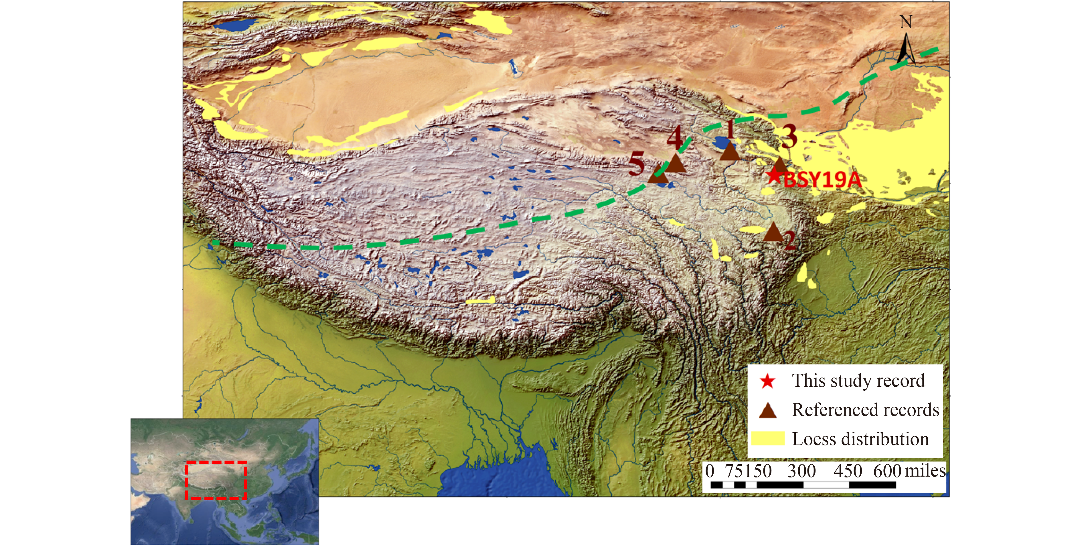
Reconstructing Holocene temperature evolution is important for understanding present temperature variations and for predicting future climate change, in the context of global warming. The evolution of Holocene global temperature remains disputed, due to differences between proxy reconstructions and model simulations, a discrepancy known as the ῾Holocene temperature conundrum᾽. More reliable and quantitative terrestrial temperature records are needed to resolve the spatial heterogeneity of existing records. In this study, based on the analysis of branched glycerol dialkyl glycerol tetraethers (brGDGTs) from a loess-paleosol sequence from the Ganjia Basin in the north-eastern Tibetan Plateau (NETP), we quantitatively reconstructed the mean annual air temperature (MAAT) over the past 12 ka. The MAAT reconstruction shows that the temperature remained low during the early Holocene (12−8 ka), followed by a rapid warming at around 8 ka. From 8 to 4 ka, the MAAT record reached its highest level, followed by a cooling trend from the late Holocene (4−0 ka). The variability of the reconstructed MAAT is consistent with trends of annual temperature records from the Tibetan Plateau (TP) during the Holocene. We attribute the relatively low temperatures during the early Holocene to the existence of ice sheets at high-latitude regions in the Northern Hemisphere and the weaker annual mean insolation at 35°N. During the mid to late Holocene, the long-term cooling trend in the annual temperature record was primarily driven by declining summer insolation. This study provides key geological evidence for clarifying Holocene temperature change in the TP.
Investigation into natural fractures is extremely important for the exploration and development of low-permeability reservoirs. Previous studies have proven that abundant oil resources are present in the Upper Triassic Yanchang Formation Chang 7 oil-bearing layer of the Ordos Basin, which are accumulated in typical low-permeability shale reservoirs. Natural fractures are important storage spaces and flow pathways for shale oil. In this study, characteristics of natural fractures in the Chang 7 oil-bearing layer are first analyzed. The results indicate that most fractures are shear fractures in the Heshui region, which are characterized by high-angle, unfilled, and ENE-WSW-trending strike. Subsequently, natural fracture distributions in the Yanchang Formation Chang 7 oil-bearing layer of the study area are predicted based on the R/S analysis approach. Logs of AC, CAL, ILD, LL8, and DEN are selected and used for fracture prediction in this study, and the R(n)/S(n) curves of each log are calculated. The quadratic derivatives are calculated to identify the concave points in the R(n)/S(n) curve, indicating the location where natural fracture develops. Considering the difference in sensitivity of each log to natural fracture, gray prediction analysis is used to construct a new parameter, fracture prediction indicator K, to quantitatively predict fracture development. In addition, fracture development among different wells is compared. The results show that parameter K responds well to fracture development. Some minor errors may probably be caused by the heterogeneity of the reservoir, limitation of core range and fracture size, dip angle, filling minerals, etc.

Evaluation of the river ecological environment can provide a basis for river management and ecological restoration. To conduct a comprehensive health assessment of the rivers in Tianjin, their biological, physical, and chemical indicators are investigated on the basis of 32 river monitoring sites from August to September 2018. The comprehensive pollution and ecological integrity indexes of the rivers are analyzed. Results of the two evaluations, compared to achieve the river ecological environment evaluation, are as follows. 1) Index of Ecological Integrity evaluation shows that among the sampling points, 18.8% are “healthy”, 28.1% are “sub-healthy”, 40.6% are “fair”, 6.3% are “poor”, and 6.3% are “very poor”. 2) The comprehensive evaluation of the chemical properties of the 32 river ecosystems in Tianjin shows severe overall river pollution and low standard water function area. Of the total sampling sites, 16 (50%) are heavily contaminated and 10 (31.3%) are moderately contaminated. Excessive chemical oxygen demand and ammonia nitrogen are the main causes of water pollution. 3) The Index of Ecological Integrity (IEI) has high correspondence with environmental factors. Pearson correlation analysis results show that the IEI index is significantly correlated with permanganate index (R= - 0.453; P = 0.023<0.05). Analysis results using BEST show that ammonia nitrogen is the best environmental parameter to explain the changes in IEI (Rho= 0.154; P = 0.02<0.05) and those using RELATE show significant correlation between the biotic index and the environmental parameter matrices (Rho= 0.154; P = 0.034<0.05).
To date, there are very few studies about the spectroscopy of lithium-containing minerals (LCMs) in the scientific community. The main objective of this study is to investigate the capability of Sentinel-2 image and FieldSpec3 spectro-radiometer in terms of mapping five important LCMs, including spodumene, lepidolite, amblygonite, petalite, and eucryptite. Therefore, first the FieldSpec3 spectro-radiometer was used to create the spectral curves of the LCMs. Then, accurate spectral analysis and comparison of the studied LCMs were performed using The Spectral Geologist (TSG) and the Prism software. These two software can show even slight difference in absorption features of different LCMs, which can discriminate and identify these minerals. Lithium-bearing rocks show absorption features at ~365, ~2200, and ~2350 nm and reflective features at ~550–770 nm. These features are consistent with Sentinel-2 bands. Therefore, the created spectral curves were utilized for calibration of Sentinel-2 optical image to detect and map the potential zones of the rock units containing minerals mentioned above in a part of the central Iranian terrane. By using the Spectral Angle Mapper (SAM) classifier module, the potential areas were demarcated. Out of the five LCMs, petalite and spodumene showed more extensive coverage in the study area. Generally speaking, the largest concentration of those LCMs can be seen in southern and centraleastern parts of the study area. The comparison between spectral curves of reference and classified minerals confirmed the high capability of Sentinel-2 image for LCMs mapping. ASTER image classification results also confirmed the presence of the LCMs, but it cannot distinguish the LCMs type successfully.

In clayey lands, swelling problem causes vertical displacements on road subbase, and finally, failure in pavement occurs due to lack of appropriate drainage systems. One popular and inexpensive method of soil stabilization is using lime. Investigations indicate that based on environmental and atmospheric conditions, the chemical reaction of lime and clayey soil is not accomplished well, owning to low temperature and high humidity. This paper aims to investigate the influence of adding rice husk ash on the reaction between soil and lime and lime reaction and determine soil physical and mechanical characteristics. Therefore, sufficient laboratory soil tests, such as Atterberg limits, compaction, California bearing ratio (CBR), and direct shear test are carried out, and the results are analyzed. The results generally indicate that adding lime and rice husk ash (RHA) causes a decrease in dry density and an increase in optimum water content. Increasing lime and RHA causes a decreasing rate in soil liquid limit and plastic limit. Adding lime and RHA to the soil causes a decrease in deformability of soil samples and gives more brittle materials. Also, this action causes an increase in shear strength. Moreover, increasing in CBR amount under the influence of increasing RHA is one of the main results of this paper.
The positive S-isotopic excursion of carbonate-associated sulfate (δ34SCAS) is generally in phase with the Steptoean positive carbon isotope excursion (SPICE), which may reflect widespread, global, transient increases in the burial of organic carbon and pyrite sulfate in sediments deposited under large-scale anoxic and sulphidic conditions. However, carbon-sulfur isotope cycling of the global SPICE event, which may be controlled by global and regional events, is still poorly understood, especially in south China. Therefore, the δ13CPDB, δ18OPDB,δ34SCAS, total carbon (TC), total organic carbon (TOC) and total sulfate (TS) of Cambrian carbonate of Waergang section of Hunan Province were analyzed to unravel global and regional controls on carbon-sulfur cycling during SPICE event in south China.
The δ34SCAS values in the onset and rising limb are not obviously higher than that in the preceding SPICE, meanwhile sulfate (δ34SCAS) isotope values increase slightly with increasing δ13CPDB in rising limb and near peak of SPICE (130–160 m). The sulfate (δ34SCAS) isotope values gradually decrease from 48.6‰ to 18‰ in the peak part of SPICE and even increase from 18‰ to 38.5% in the descending limb of SPICE. The abnormal asynchronous C-S isotope excursion during SPICE event in the south China was mainly controlled by the global events including sea level change and marine sulfate reduction, and it was also influenced by regional events such as enhanced siliciclastic provenance input (sulfate), weathering of a carbonate platform and sedimentary environment. Sedimentary environment and lithology are not the main reason for global SPICE event but influence the δ13CPDB excursion-amplitude of SPICE. Sea level eustacy and carbonate platform weathering probably made a major contribution to the δ13CPDB excursion during the SPICE, in particularly, near peak of SPICE. Besides, the trilobite extinctions, anoxia, organic-matter burial and siliciclastic provenance input also play an important role in the onset, early and late stage of SPICE event.

This study undertook verification of the applicability and accuracy of wind data measured using a WindCube V2 Doppler Wind Lidar (DWL). The data were collected as part of a field experiment in Zhoushan, Zhejiang Province (China), which was conducted by Shanghai Typhoon Institute of China Meteorological Administration during the passage of Super Typhoon Lekima (2019). The DWL measurements were compared with balloon-borne GPS radiosonde (GPS sonde) data, which were acquired using balloons launched from the DWL location. Results showed that wind speed measured by GPS sonde at heights of<100 m is unreliable owing to the drift effect. Optimal agreement (at heights of>100 m) was found for DWL-measured wind speed time-averaged during the ascent of the GPS sonde from the ground surface to the height of 270 m (correlation coefficient: 0.82; root mean square (RMS): 2.19 m·s−1). Analysis revealed that precipitation intensity (PI) exerts considerable influence on both the carrier-to-noise ratio and the rate of missing DWL data; however, PI has minimal effect on the wind speed bias of DWL measurements. Specifically, the rate of missing DWL data increased with increasing measurement height and PI. For PI classed as heavy rain or less (PI<12 mm·h−1), the DWL data below 300 m were considered valid, whereas for PI classed as a severe rainstorm (PI>90 mm·h−1), only data below 100 m were valid. Up to the height of 300 m, the RMS of the DWL measurements was nearly half that of wind profile radar (WPR) estimates (4.32 m·s−1), indicating that DWL wind data are more accurate than WPR data under typhoon conditions.
The predictions for Super Typhoon Lekima (2019) have been evaluated from official forecasts, global models, regional models and ensemble prediction systems (EPSs) at lead times of 1–5 days. Track errors from most deterministic forecasts are smaller than their annual mean errors in 2019. Compared to the propagation speed, the propagation direction of Lekima (2019) was much easier to determine for the official agency and numerical weather prediction (NWP) models. The National Centers for Environmental Prediction Global Ensemble Forecast System (NCEP-GEFS), Japan Meteorological Agency Global Ensemble Prediction System (JMA-GEPS) and Meteorological Service of Canada Ensemble System (MSC-CENS) are underdispersed, and the Shanghai Typhoon Institute Typhoon Ensemble Data Assimilation and Prediction System (STI-TEDAPS) is overdispersed, while the ensemble prediction system from European Centre for Medium-Range Weather Forecasts (ECMWF) shows adequate dispersion at all lead times. Most deterministic forecasting methods underestimated the intensity of Lekima (2019), especially for the rapid intensification period after Lekima (2019) entered the East China Sea. All of the deterministic forecasts performed well at predicting the first landfall point at Wenling, Zhejiang Province with a lead time of 24 and 48 h.
Carbon capture, utilization, and storage (CCUS) have garnered extensive attention as a target of carbon neutrality in China. The development trend of international CCUS projects indicates that the cluster construction of CCUS projects is the main direction of future development. The cost reduction potential of CCUS cluster projects has become a significant issue for CCUS stakeholders. To assess the cost reduction potential of CCUS cluster projects, we selected three coal-fired power plants in the coastal area of Guangdong as research targets. We initially assessed the costs of building individual CCUS projects for each plant and subsequently designed a CCUS cluster project for these plants. By comparing individual costs and CCUS cluster project costs, we assessed the cost reduction potential of CCUS cluster projects. The results show that the unit emission reduction cost for each plant with a capacity of 300 million tonnes per year is 392.34, 336.09, and 334.92 CNY/tCO2. By building CCUS cluster project, it could save 56.43 CNY/tCO2 over the average cost of individual projects (354.45 CNY/tCO2) when the total capture capacity is 9 million tonnes per year (by 15.92%). Furthermore, we conducted a simulation for the scenario of a smaller designed capture capacity for each plant. We found that as the capture scale increases, the cost reduction potential is higher in the future.

Following flooding disasters, satellite images provide valuable information required for generating flood inundation maps. Multispectral or optical imagery can be used for generating flood maps when the inundated areas are not covered by clouds. We propose a rapid mapping method for identifying inundated areas based on the increase in the water index value between the pre- and post-flood satellite images. Values of the Normalized Difference Water Index (NDWI) and Modified NDWI (MNDWI) will be higher in the post-flood image for flooded areas compared to the pre-flood image. Based on a threshold value, pixels corresponding to the flooded areas can be separated from non-flooded areas. Inundation maps derived from differencing MNDWI values accurately captured the flooded areas. However the output image will be influenced by the choice of the pre-flood image, hence analysts have to avoid selecting pre-flood images acquired in drought or earlier flood years. Also the inundation maps generated using this method have to be overlaid on the post-flood satellite image in order to orient personnel to landscape features. Advantages of the proposed technique are that flood impacted areas can be identified rapidly, and that the pre-existing water bodies can be excluded from the inundation maps. Using pairs of other satellite data, several maps can be generated within a single flood which would enable emergency response agencies to focus on newly flooded areas.
Liangjia Village earth fissure, one of the 79 earth fissures along the Kouzhen–Guanshan fault located in the northern Weihe Basin, causes severe damage to buildings and farmlands. Since the late 1950s, 40 earth fissures have occurred in a similar east–west (EW) direction parallel to the Kouzhen–Guanshan fault, and a further 39 earth fissures have occurred with north-west, east-north, or north-east orientations intersecting the fault. In this study, a case study of Liangjia Village earth fissure was conducted to investigate the mechanisms of fissure generation in detail. Geotechnical and geophysical methods including measurements, trenching, drilling, and seismic exploration were used to reveal the basic characteristics, geological background, and origin model of the Liangjia Village earth fissure. This earth fissure, with a total length of 800 m in 2014, runs EW parallel to the Kouzhen–Guanshan fault, and it has damaged buildings and farmlands by forming sinkholes, gullies, subsidence, and a scarp. The trenching results indicated that this fissure underwent multi-phase activity. Analysis of geological drilling and shallow seismic profiling results showed that the fissure also possessed characteristics of a syn-sedimentary fault. Regarding its genesis, the fissure was formed through the combined actions of three factors: an earthquake created the fissure, the Kouzhen–Guanshan fault controlled its development, and loess erosion and groundwater runoff subsequently enlarged the fissure. Regional extension first generated many buried faults along the hanging wall of the Kouzhen–Guanshan fault before seismic activity caused the buried faults to propagate to the surface, where loess erosion and groundwater runoff promoted the formation of the current earth fissure.